All roads lead to Rome: Scientists discover they were a lot longer than previously known and some still exist
New images have revealed previously unknown information about how the Romans travelled long distances.
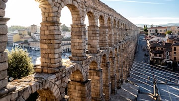

A newly published research project has drastically reshaped our understanding of the road network built by Roman Empire. According to the researchers, the empire’s roadways covered nearly 186 000 miles (≈ 300 000 km), 50 % more than was previously estimated.
What makes this revelation possible is a blend of old and new techniques: Archaeologists sifted through milestones, ancient texts and archival records, then cross‑referenced these with satellite images and declassified aerial photographs to trace what’s left of long‑lost routes.
Tom Brughmans, an archaeologist and co-author of the study published in Scientific Data, said: “It becomes a massive game of connecting the dots on a continental scale.”
“This is in fact a hugely constructive finding”
“This was a huge surprise and a sobering realisation: Roads are one of the most enigmatic topics in Roman archaeology and history, they were all over the place, we have proverbs like ‘all roads lead to Rome’. How can it be that we only know the location of 3 percent with certainty?” Brughmans told ScienceAlert. “This is in fact a hugely constructive finding. Thanks to our work, we know that localizing Roman roads precisely requires more research attention.”
“The main contribution of the project is that it brings together all of that research about Roman road locations in an open and accountable way: Each of the 14,769 road segments includes the sources used to localise it and an expression of the certainty of the location,” he added.
The map is named Itiner-e, and has been made publicly available by those who worked on it: “This is the first open dataset that combines research about the location of all Roman roads across the entire empire. They have been studied for over 200 years, and we should have a reliable resource that makes these scholarships available to everyone,” Brughmans said.
This expanded view matters because those “secondary” roads which were once largely ignored help explain how the empire functioned at ground‑level. Supply chains, troop movements and even the spread of ideas or disease all depended on a network that was far more extensive than the major roads on their own.
Leptis Magna.. Its ruins are located in Khoms, Libya. The site is one of the most spectacular and unspoiled Roman ruins in the Mediterranean. pic.twitter.com/qfMeHd93y5
— Roman History (@romanhistory1) May 31, 2018
Related stories


However, the authors point out that only a small fraction of the mapped routes—2–3 %—can currently be classified as “high‑certainty”. The majority remain classified as conjectured based on indirect data, meaning the exact location or continuous use of many roads remains to be verified, and further research is needed to fill the gaps.
Get your game on! Whether you’re into NFL touchdowns, NBA buzzer-beaters, world-class soccer goals, or MLB home runs, our app has it all. Dive into live coverage, expert insights, breaking news, exclusive videos, and more – plus, stay updated on the latest in current affairs and entertainment. Download now for all-access coverage, right at your fingertips – anytime, anywhere.
Complete your personal details to comment